
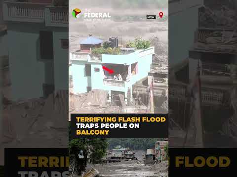
A short video can show terrifying water, people sheltering indoors and a valley apparently having a very bad day. It cannot, by itself, establish the essentials: the precise location, when the footage was filmed, the scale of damage, whether routes are closed or how many people may be affected.
That distinction matters around the Nepal–Tibet border, where dramatic terrain and patchy communications can turn a local weather emergency into a fast-moving online story. Reports linked to a flash flood in the area have drawn attention to possible disruption, but the material available with the report does not provide independently verified details on casualties, evacuations, infrastructure damage or the operational status of a specific border crossing.
For travellers, families and tour operators, the sensible response is not panic. It is caution with a decent signal-to-noise filter.
What is known — and what still needs official confirmation
The available reference material points to a reported flash-flood incident near the Nepal–Tibet border, with people apparently remaining indoors as water conditions worsened. Beyond that broad indication, key facts should be treated as unconfirmed until they are issued by relevant authorities or established by reliable on-the-ground reporting.
That includes:
- the exact community or valley affected;
- the timing and duration of the flooding;
- any injuries, deaths or missing-person reports;
- the extent of damage to homes, bridges, roads and power or communications links;
- whether rescue operations or formal evacuations have been ordered; and
- the status of border procedures and cross-border transport.
This may sound fussy. In a mountain emergency, fussy is a survival skill. Old images are regularly recirculated during major weather events, and a road closed in one valley may be entirely unrelated to a crossing several hours away. A viral clip is a warning sign, not a transport bulletin.
Why flash floods are so dangerous in the Himalayas
Flooding in Himalayan terrain is rarely a slow, polite rise in water levels. Intense rain can rapidly funnel down steep slopes and narrow river valleys, carrying mud, rocks, timber and debris. Landslides can block streams and roads; damaged slopes can remain unstable long after the rain appears to have eased. The landscape is spectacular precisely because it has very little interest in behaving like a flat, predictable map.
Nepal’s monsoon season typically brings the highest rain-related risk, though hazardous conditions can also arise from local storms and changing mountain weather outside the most familiar seasonal window. In high-altitude areas, weather systems, road conditions and visibility can shift far faster than an itinerary designed in a café in Kathmandu, Lhasa or London.
Roads are particularly vulnerable. A single landslide or washed-out bridge can isolate settlements and interrupt supplies, while secondary routes may be unsuitable or unavailable. For cross-border journeys, the complication is doubled: a route must be safe and open on both sides, and official immigration arrangements may change with little notice during an emergency.
Travel disruption: what to expect before changing your plans
No specific border closure has been confirmed in the information available for this report. Travellers should therefore avoid assuming either that a crossing is shut or that it is functioning normally. Both assumptions can be expensive, and one can be dangerous.
Anyone planning overland travel between Nepal and Tibet, or travelling towards Himalayan border districts, should check directly with their tour operator, transport provider and the relevant official authorities before leaving. If a journey depends on a particular mountain road, ask a very plain question: is this route operating today, for passenger travel, and has that been confirmed by the road or local administration?
Do not rely only on a booking confirmation. Operators can be working from the same incomplete information as everybody else. Request the latest departure plan, cancellation terms, accommodation contingency and alternative routing in writing where possible.
A practical traveller checklist
- Keep extra drinking water, food, warm layers, medication, a torch and a charged power bank accessible.
- Carry physical copies of passports, permits, visas and insurance details; network access may disappear when it is least convenient.
- Build spare days into mountain itineraries rather than scheduling an international flight immediately after an overland crossing.
- Tell someone outside the affected area your route, accommodation and expected check-in time.
- Do not attempt to walk, drive or ride through floodwater, even if locals or other travellers appear to be doing so. Floodwater has a superb talent for hiding collapsed road edges.
- Follow evacuation instructions from local authorities immediately, and stay away from riverbanks, bridges and slopes after heavy rain.
For people already in the region: decisions that matter most
Visitors already near an affected area should prioritise local instructions over itinerary pressure. A trek, jeep transfer or border appointment can be rearranged; being stranded on the wrong side of a river is a much poorer use of the afternoon.
Move to safer ground if advised, avoid basements and low-lying river corridors, and keep clear of damaged buildings, downed lines and visibly unstable slopes. If communications are limited, hotel staff, guides, transport operators and local community leaders may have the most immediate practical information, but official emergency messages should take precedence.
Contact your embassy or consular service if you are unable to reach family, have lost travel documents or need assistance navigating an extended disruption. Travel insurance providers should also be notified early if accommodation, transport or medical arrangements are affected.
The larger issue: resilience where the mountains meet the weather
Every flood report from the Himalayan region is also a reminder that resilience is not an abstract policy word. It means passable roads, dependable alerts, robust bridges, safe shelters, trained local responders and communication systems that work when weather knocks out the usual conveniences.
Communities in these valleys often live with seasonal hazards as a fact of geography, while tourism and cross-border trade depend on infrastructure that can be disrupted by a single severe event. Better forecasting, locally understood warning systems and risk-aware construction can reduce harm, but no system removes the need for travellers to respect the conditions.
For now, the responsible picture is straightforward: flooding has been reported near the Nepal–Tibet border, while the operational and humanitarian details require confirmation from official sources. Those travelling through the region should verify every stage of their route, allow time for disruption and treat heavy rain as a reason to slow down—not an invitation to collect dramatic footage for the group chat.